 [posted on National Snow & Ice Data Center, March 22, 2017] The National Snow and Ice Data Center (NSIDC) is part of the Cooperative Institute for Research in Environmental Sciences at the University of Colorado Boulder. NSIDC scientists provide Arctic Sea Ice News & Analysis content, with partial support from NASA.
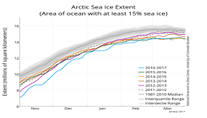
BOULDER, Colo., March 22, 2017—Arctic sea ice was at a record low maximum extent for the third straight year, according to scientists at the National Snow and Ice Data Center (NSIDC) and NASA.
On March 7, sea ice extent over the Arctic Ocean reached 14.42 million square kilometers (5.57 million square miles), then gradually began its decline with the start of the melt season. The sea ice maximum refers to the point at which sea ice is at its highest seasonal extent. The sea ice minimum will occur sometime in September.
The 2017 Arctic maximum is now the lowest in the 38-year satellite record, beating 2015’s maximum of 14.517 million square kilometers (5.605 million square miles) on February 25, and 2016’s maximum of 14.52 million square kilometers (5.606 million square miles).
NSIDC scientists said a very warm autumn and winter contributed to the record low maximum, with air temperatures 2.5 degrees Celsius (4.5 degrees Fahrenheit) above average over the Arctic Ocean. The overall warmth was punctuated by a series of extreme winter heat waves over the Arctic Ocean, continuing the pattern also seen in the winter of 2015.
NSIDC director Mark Serreze said, “I have been looking at Arctic weather patterns for 35 years and have never seen anything close to what we’ve experienced these past two winters.”
Data from the European Space Agency’s CryoSat-2 satellite showed that this winter’s ice cover was slightly thinner compared to the past four years. Data from the University of Washington’s Pan-Arctic Ice Ocean Modeling and Assimilation System also showed that the Arctic’s ice volume was unusually low for this time of the year.
“Thin ice and beset by warm weather—not a good way to begin the melt season,” said NSIDC lead scientist Ted Scambos.
NSIDC scientist Julienne Stroeve said, “Such thin ice going into the melt season sets us up for the possibility of record low sea ice conditions this September.” Stroeve is also professor of polar observation and modeling at the University College London.
“While the Arctic maximum is not as important as the seasonal minimum, the long-term decline is a clear indicator of climate change,” said Walt Meier, a scientist at the NASA Goddard Space Flight Center Cryospheric Sciences Laboratory and an affiliate scientist at NSIDC.
This animation shows the Arctic wintertime sea ice extent from January 2017 through the maximum on March 7, 2017. Credit: NASA.
Arctic sea ice melts and regrows in an annual cycle, with freezing throughout the winter months and melting in the spring and summer. The ice cover generally reaches its maximum extent sometime in late February or March. After that, ice melts through the summer, hitting a low point or minimum extent, in early or mid-September.
The September Arctic minimum began drawing attention in 2005 when it first shrank to a record low extent over the period of satellite observations. It broke the record again in 2007, and then again in 2012. The Arctic maximum has typically received less attention. That changed in 2015 when the maximum extent also reached a record low.
In the Southern Hemisphere, sea ice reached its minimum extent for the year on March 3 at 2.11 million square kilometers (813,000 square miles). This year’s Antarctic minimum extent was the lowest in the satellite record. However, Antarctic ice extent is highly variable; two and a half years ago, extent was at the highest level in the satellite record.
NSIDC will release a full analysis of the winter season in early April, once monthly data are available for March.
Read the NSIDC analysis of the Arctic maximum here.
Read NASA’s release here.
Read the NOAA Climate.gov release here.
